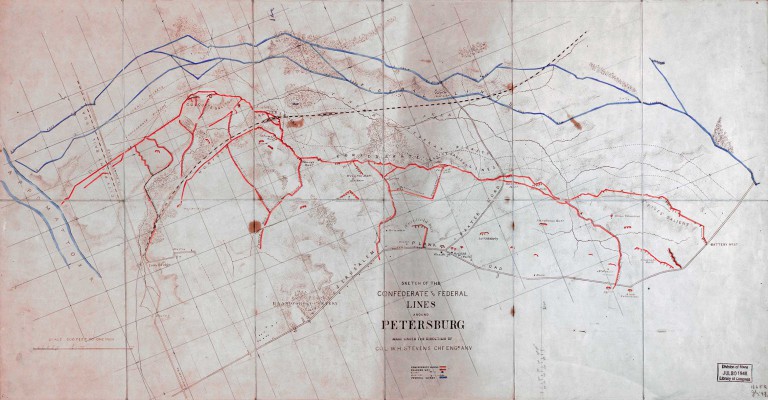
Sketch of the Confederate and Federal lines around Petersburg
Contributor Names: Stevens, W. H. (Walter H.)
Created / Published: [S.l. : s.n., 186-]
Subject Headings
 -Petersburg (Va.)--History--Siege, 1864-1865 -Petersburg (Va.)--History--Siege, 1864-1865
-United States--Virginia--Petersburg
Notes
-Sun print.
-Photocopy (positive).
-Relief shown by hachures.
-LC Civil War maps (2nd ed.), 610
-Description derived from published bibliography.
-Available also through the Library of Congress Web site as a raster image.
-Indicates roads, picket lines, houses, names of residents, drainage, and vegetation.
-Indicates Union and Confederate works hand-colored blue and red respectively. Indicates location of Confederate covered ways, guns, and mortars.
-In ink on verso: 114. DLC
-Errata note (in manuscript) on verso. DLC
-This map was in the possession of Jedediah Hotchkiss at the time of his death. Major Hotchkiss served as a topographic engineer with the Army of Northern Virginia.This map was acquired by the Library of Congress in 1948 with the purchase of the papers and maps of Jedediah Hotchkiss. DLC
Medium
1 map : photocopy; 41 x 79 cm.
Call Number
G3884.P4S5 186- .S4
Repository
Library of Congress Geography and Map Division Washington, D.C. 20540-4650 USA
Digital Id
g3884p cw0610000 http://hdl.loc.gov/loc.gmd/g3884p.cw0610000
Library of Congress Catalog Number
2006629756
http://www.loc.gov/resource/g3884p.cw0610000/
http://lccn.loc.gov/2006629756
|
|
 chapter 9