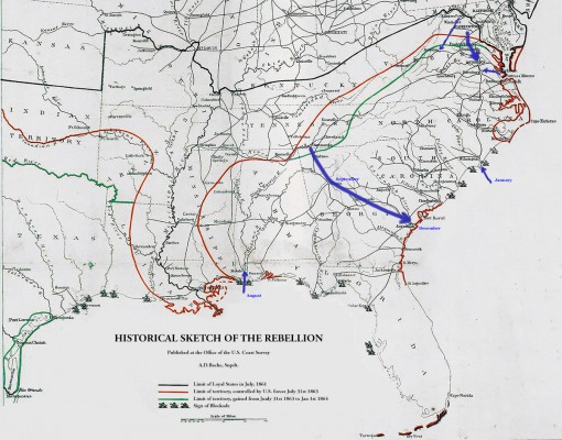
adapted from
Historical sketch of the rebellion
Contributor Names: Lindenkohl, H. (Henry)
Created / Published: [S.l.], Office of the U.S. Coast Survey, [1864]
Subject Headings
 - - United States--History--Civil War, 1861-1865 United States--History--Civil War, 1861-1865
 - - United States United States
Notes
 - - Scale 1:5,850,000. Scale 1:5,850,000.
 - - LC Civil War Maps (2nd ed.), 49 LC Civil War Maps (2nd ed.), 49
 - - "Limit of loyal states in July, 1861, limit of territory "Limit of loyal states in July, 1861, limit of territory
 controlled by U.S. forces July 31st 1863, [and] limit of territory controlled by U.S. forces July 31st 1863, [and] limit of territory
 gained from July 31st 1863 to Jan. 1st 1864" indicated by colored gained from July 31st 1863 to Jan. 1st 1864" indicated by colored
 lines. Small ships denote the extent of the naval blockade. lines. Small ships denote the extent of the naval blockade.
 - - "Population census 1860" in the lower right corner. "Population census 1860" in the lower right corner.
 - - See also Civil War Maps entry nos. 34, 35, 36, 39, 40 and 40.1. See also Civil War Maps entry nos. 34, 35, 36, 39, 40 and 40.1.
 - - Another copy is in the James A. Garfield papers, Manuscript Another copy is in the James A. Garfield papers, Manuscript
 Division, L.C., series 8, container no. 1. Division, L.C., series 8, container no. 1.
 - - Description derived from published bibliography. Description derived from published bibliography.
 - - Available also through the Library of Congress web site as raster image. Available also through the Library of Congress web site as raster image.
Medium
 1 map, col., 47 x 45 cm. 1 map, col., 47 x 45 cm.
Call Number
 G3701.S5 1863 .L5 G3701.S5 1863 .L5
Repository
 Library of Congress Geography and Map Division Washington, D.C. 20540-4650 Library of Congress Geography and Map Division Washington, D.C. 20540-4650
Digital Id
 g3701s cw0049000 http://hdl.loc.gov/loc.gmd/g3701s.cw0049000 g3701s cw0049000 http://hdl.loc.gov/loc.gmd/g3701s.cw0049000
Library of Congress Catalog Number
 99447147 99447147
http://lccn.loc.gov/99447147
|
|
 chapter 6


 chapter 6


