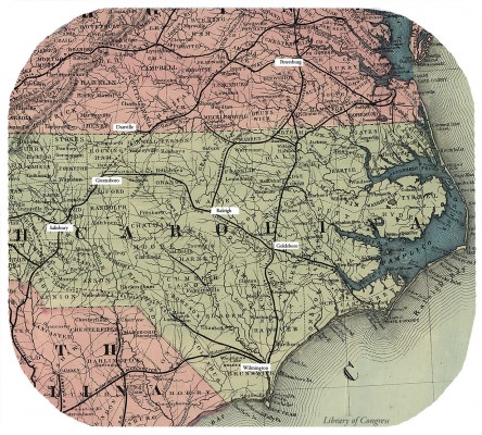
Adapted from (cropped and labeled)
Hazard's rail road & military map of the southern states.
Contributor Names
Philadelphia Board of Trade. Committee on Inland Transportation.
Created / Published
Philadelphia, Drawn & engraved by P.S. Duval & Son, Lithrs., 1863, c1862.
Subject Headings
Railroads--Southern States
United States--Southern States
Notes
Scale ca. 1:1,880,000.
"Entered according to Act of Congress in the year 1862, by Thomas Kimber, Jr."
LC Civil War maps (2nd ed.), 44
Description derived from published bibliography.
Shows railroads, forts, location and dates of engagements, state and
 county boundaries, roads, towns, and rivers. county boundaries, roads, towns, and rivers.
Available also through the Library of Congress Web site as a raster image.
The Geography and Map Division has another copy which has been annotated in
 color to indicate "gauges of southern rail roads." The additions were color to indicate "gauges of southern rail roads." The additions were
 "compiled under direction of Lieut. Col. J. N. Macomb, A.D.C., Chief Top. Engr." "compiled under direction of Lieut. Col. J. N. Macomb, A.D.C., Chief Top. Engr."
 and "corrected to date Feby. 9th 1864." The map was addressed to "Mr. Nicolay," and "corrected to date Feby. 9th 1864." The map was addressed to "Mr. Nicolay,"
 apparently John George Nicolay, President Lincoln's private secretary. apparently John George Nicolay, President Lincoln's private secretary.
 The copy is partially mutilated; three of the four corners are missing. DLC The copy is partially mutilated; three of the four corners are missing. DLC
Listed in A. M. Modelski's Railroad maps of the United States
(Washington, Library of Congress, 1975), no. 142.
For 1862 edition, see Civil War Maps entry no. 31.5.
Medium
col. map 77 x 129 cm.
Call Number
G3861.P3 1863 .P5
Repository
Library of Congress Geography and Map Division Washington, D.C. 20540-4650 USA dcu
Digital Id
g3861p cw0044000 http://hdl.loc.gov/loc.gmd/g3861p.cw0044000
Library of Congress Catalog Number
00552203
http://lccn.loc.gov/00552203
|
|
 chapter 16


 chapter 16


